
Showing posts with label Antarctica. Show all posts
Showing posts with label Antarctica. Show all posts
Saturday, July 8, 2023

Friday, December 9, 2022
An Example of Science at it's Best?

We live on a Sphere that spins at 1000 MPH,
that moves at 20,000 MPH around the Sun.
The Sun shoots at 200,000 MPH around the 'Milky Way' Galaxy,
that moves at over a Million MPH in an ever expending Universe.
And even though it doesn't feel like it and the stars follow us in unison,
it looks like this:
Why is the education system so anchored on theories at a young age?
The 'Scientific Method' anticipates a certain level of proof. Although none of the Heliocentric model was ever proven, the Sphere is a prominent fixture of all classrooms as early as possible.
ADMIRAL BYRD FULL INTERVIEW

THE PATENTED 1892 GLEASON'S EARTH MAP

WWII Airman's Map
Thursday, July 13, 2017
Antarctica the Forbidden Zone
Job 38
8 Or who shut up the sea with doors, when it brake forth, as if it had issued out of the womb?
9 When I made the cloud the garment thereof, and thick darkness a swaddlingband for it,
10 And brake up for it my decreed place, and set bars and doors,
11 And said, Hitherto shalt thou come, but no further: and here shall thy proud waves be stayed?
12 Hast thou commanded the morning since thy days; and caused the dayspring to know his place;
13 That it might take hold of the ends of the earth, that the wicked might be shaken out of it?
Antarctica is the most harsh place on Earth.

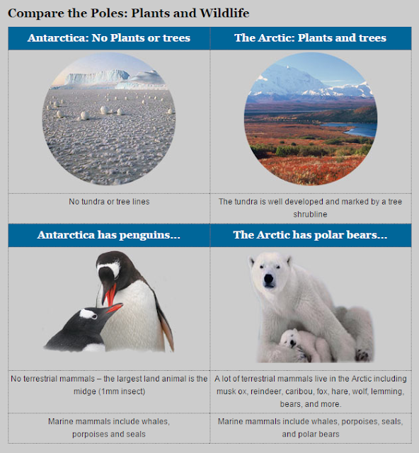
Arctic North Pole: The animals include the reindeer, polar bear, Arctic fox, narwhal, walrus, seal, ox, moose, orca, and snowy owl. The Alaskan malamute is a powerful sled dog from Alaska. This small, white fox lives farther north than any other land animal. This white hare lives in the Arctic and has huge hindfeet. Approximately 1,700 species of plants live on the Arctic tundra, including flowering plants, dwarf shrubs, herbs, grasses, mosses, and lichens. The tundra is characterized by permafrost, a layer of soil and partially decomposed organic matter that is frozen year-round.
Antarctic South Pole: No terrestrial mammals. No plants or trees.
Antarctica is pretty much a forbidden zone. The first Antarctic Treaty was signed in Washington on 1 December 1959 by the twelve countries whose scientists had been active in and around Antarctica.
53 Nations have now entered the treaty.
Updated November 5th 2016, the treaty now bans Private ships.
What Admiral Byrd said about Antarctica
TV interview 1954 Q and A
Q- Is there any unexplored land on this Earth, that might appeal to adventurous young Americans?
A- Yes, there is. Not at the North pole......
But strangely enough, there is left in the world today an area as big as the United States, that's never been seen by human beings, and that's beyond the pole, on the other side of the South pole, from middle America. And I think it's quite astonishing .....
On the other side of the South pole?


Would there be an ice barrier that contains the oceans?
No private party has come alive to tell the tale. The 53 countries stationed 'around' Antarctica are closely monitoring any intrusion.
It is possible to visit Antarctica, but only accompanied of members of the monitoring parties, North Korean style. No one can attest as to what is beyond the Ice after a couple hundred of miles.
 |
The Hawaiian gazette., January 11, 1907, Page 2, Image 2 - http://chroniclingamerica.loc.gov/lccn/sn83025121/1907-01-11/ed-1/seq-2/ |
Too many questions will remain unanswered, until someone breaks through the Antarctic Blockade.
A few weeks ago, I uttered a prayer to God. I asked God to give us his people the means to expose the Conspiracies of his enemies. Being convinced that the Earth is Flat, that Antarctica is 'the barrier Ice Wall' that contains the seas, and prevent us from wandering away from our home, I asked God to open gates in the barrier to allow us to go forward and discover his stretched out creation, to prove the ignominious conspiracy against us.
Could the broken Ice shelf be his answer? Will it expose paths to the remaining Lands?
Wednesday, February 1, 2017
The Wall
By J.P.
"Sent to McMurdo research station in August of 1998.
When we weren't busy de-icing the aircraft and working on them, we had time to hang out with the scientists at the research station.
When we weren't busy de-icing the aircraft and working on them, we had time to hang out with the scientists at the research station.
The military unit attached to McMurdo was small and we didn't have our own separate facilities. We didn't have a PX, or a media center. There was no chapel or Chaplin. And we didn't have or our own separate mail room. We just had to share the same facilities with the scientists and researchers. So over time I got to be friends with a few of them.
They had two different kinds of ice that they worked on and studied. One kind of ice was the normal kind that we've all seen. They took cores of it out of bore holes in the ground. Just like normal ice it was mostly clear or sometimes white, and it would melt into liquid water if it got warm. The whole area of Antarctica is covered in this kind of ice. But that wasn't their main kind of ice. The only time I ever saw them actually studying normal ice was when a film crew from National Geographic came by.
The rest of the time, which was most of the time, the scientists were studying something they called sky ice.
This stuff was totally different.
We were never allowed to go into the laboratory areas of the station, because the labs had to be kept super clean and they said it would mess up their work if they risked letting too many people in the lab. But one time one of the researchers that I was friends with showed me a piece of sky ice. You couldn't touch the stuff with your bare hands because it was so cold.
And it wasn't clear or white like normal ice. It was solid blue. He said that's why they call it sky ice, because it was the exact same color as the sky.
We had to wear our thick heavy "going outside" gloves to handle it. The stuff was so cold it would instantly freeze your skin if you touched it. I don't remember what temperature he said it was. But it was something like hundreds of degrees below zero. WAY colder than the normal ice that was outside.
He had to carry it in a metal bottle that was kinda like a thermos. He let me play with a piece of it for a while. It felt lighter than a piece of normal ice of the same size, like it wasn't very heavy at all. It almost felt like you could throw it up in the air and it would just float back down, but I didn't try that. And it was also a little flexible when I tried to bend it. It didn't break like normal ice would. And even for a small piece, you couldn't see through it. It was solid blue right from the surface.
And here's the really weird part. It didn't melt into water. When it got warm, because we had it inside, it just started to shrink. It got smaller and smaller, but my glove never got wet. And there was no water on the floor. The stuff just turned into thin air when it got warm, and vaporized.
He said that was the reason why they had to study the stuff right there in Antarctica. You couldn't take sky ice back to America to study it, because it was almost impossible to keep it cold enough during transit. It would always vaporize into air and you'd have nothing left when you got back to the US. He said Russian scientists had discovered the same problem when they tried to take sky ice back to Russia. So that was why they all had research stations in Antarctica.
After maybe 15 minutes of handling the piece of sky ice, it was almost completely gone. Just a tiny little bit was left. And my glove was dry the whole time.
I'd never seen anything like it before or since. And that's unusual because I've always had an interest in scientific things. I think that's even why I got selected to go to Antarctica, because a big part of the interview was about science and what I believed about things. So I really thought it was cool to see something I'd never heard of before.
The whole time I was at McMurdo I heard people talk about "the wall" like that was a special place. It's pretty common to find ice walls and ice cliffs all over Antarctica. The whole place is ice. But it's all just normal white or clear ice, so I asked my friend where they get the sky ice from, and he said it comes from "the wall".
I don't remember exactly how he described it, but apparently there's a huge wall of sky ice in Antarctica. He said it was hundreds of miles inland from the coast. I never got to see it myself because I was only stationed to McMurdo. I didn't get to go out on expeditions. He said it was the biggest natural structure in the world.
He said that in the 1960's the US Army had a plan to bore a tunnel into the wall. But they didn't have a boring machine that could handle super cold temperatures. So they had a whole testing project in Greenland where they developed ice tunnels and invented new boring machines that could operate in super cold temperatures. Like they did this whole big thing in Greenland just for practice. I'm not an expert on that but that's just what he told me. Then once they had the new boring machine figured out, they brought it to the wall in Antarctica.
He said that the machine bored a tunnel, I don't remember exactly, like 5 or 10 miles into the wall, but that they never broke through the other side of the wall, and that they still don't know how thick the wall is even to this day.
And I'm probably not remembering this part correctly, but I think he said that at first, the floor of the tunnel was solid rock, but after a mile or two in, the floor was sky ice. Like it was sky ice underneath after a certain point. Or something like that.
And I'm probably not remembering this part correctly, but I think he said that at first, the floor of the tunnel was solid rock, but after a mile or two in, the floor was sky ice. Like it was sky ice underneath after a certain point. Or something like that.
And apparently the wall slowly builds itself back up after you cut it, because after a year or so, the tunnel had shrunk smaller all by itself. They had to leave the boring machine inside the wall because the tunnel shrunk too small to get it back out. And after a few decades the tunnel was completely gone.
Like, that part of the wall was solid again.
He said that now the scientists were trying to use technology to figure out how thick the wall is. He said something about putting earthquake sensors all along the wall, and that somehow you could measure the signal from an earthquake to see how thick the wall is, but he kinda lost me on that part.
I never really thought about any of that after I left. It was really weird stuff, but I didn't think it was a big deal at the time. But then a few weeks ago I saw a map of the wall in Antarctica. Except the map was all flat and crazy looking, and it showed the wall going all the way up over the whole earth.
So since then I've been trying to learn more about the sky ice that I saw, and the wall that I heard about, but I can't find anything at all."

Monday, November 28, 2016
Kingdoms, Empires and Explorers
486 AD “Voyage of Brendan” – Saint Brendan, also known as Saint Brendon, Brendan the Bold, and Brendan the Voyager was an Irish abbot, monastery founder, and legendary sea voyager. He sailed in the Atlantic Ocean, traveling to the Hebrides (islands off the west coast of Scotland), Scotland, and perhaps to Wales and Brittany (the northwestern coast of France along the English Channel). He may have also sailed to the Canary Islands (off the northwest coast of Africa), the Azores (islands far off the coast of Portugal), and Iceland.
 |
| Map of expansion of Caliphate |
622 - The Muslim Empire began with the Islamic Prophet Muhammad, It’s expansion under the Umayyad Caliphate (7th century), extended conquests to southern Europe, including North Africa, Caucasus and central Asia until 1099.

668 - The 3 Kingdoms of the Korean Peninsula were unified under the Kingdom of Silla.
950 - Eric the Red, Viking explorer. was the first European to sail to Greenland. He sailed from Iceland in 982 and led a group of colonists to Greenland in 985-986.
1000 - ERIKSSON LEIF, one of the sons of the explorer Eric the Red, was possibly the first European to sail to North America. Leif sailed north from the southern tip of Greenland, then went south along the coast of Baffin Island down to Labrador, and then landed in what is now called Newfoundland (which he called Vinland). Ericsson was probably preceded to Vinland by the Icelandic explorer Bjarni Herjulfsson, who spotted the coast of North America when blown off course from Iceland to Greenland (but he did not go ashore).
1200
– The Aztecs. The Nahua people and the Aztlan migrants formed what was to become the Aztec Empire. It ended with the Spanish conquest under Hernan Cortes. (15th century)
– The Incas begun in the area of Cusco Peru. They were conquered by the Spanish Francisco Pizarro in the mid 15th century.

1206 Genghis Khan proclaimed ruler of the Mongols. Followed 2 centuries of conquest to create the largest contiguous land Empire in history. Civil war and division ended this huge Empire.
1271 Marco Polo Italian voyager and merchant who was one of the first Europeans to travel across Asia through China, visiting the Kublai Khan in Beijing.

1492 Christopher Columbus was an Italian explorer who sailed across the Atlantic Ocean, hoping to find a route to India (in order to trade for spices). Sailing for King Ferdinand II and Queen Isabella of Spain, Columbus led an expedition with three ships, the Niña, the Pinta, and the Santa Maria to the Caribbean and South America.
1497
– John Cabot explored the Canadian coastline and named many of its islands and capes. The mission’s purpose was to search for a Northwest passage across North America to Asia (a seaway to Asia).
– Vasco da Gama, Portuguese explorer who found a route from Spain to the East. He sailed from Lisbon, Portugal, around Africa’s Cape of Good Hope, to India (and back) in 1497-1499. At that time, many people thought that it was impossible to do this since they thought that the Indian Ocean was not connected to any other seas.
16th Century saw the rise of the Spanish Empire. It became a global power by the 18th century with the greatest territorial expansion.
1507 Ojeda and Amerigo Vespucci discovered the mouth of the Amazon and Orinoco Rivers in South America, thinking it was part of Asia. On his second expedition (sailing for Portugal, 1501-02) he mapped some of the eastern coast of South America, and came to realize that it not part of Asia, but a New World.
1519-1522 Ferdinand Magellan, Portuguese explorer who led the first expedition that sailed around the Earth (1519-1522). Magellan also named the Pacific Ocean.
1607 The First American Colonies
Late 16th Century
– The British Empire, a Global power by the late 1800’s. Largest Empire in history.
– The French Colonial Empire, became Napoleon’s conquest Empire in the early 1800’s.
17th Century Russian Empire stretching over 3 continents, defeated Napoleon’s ambitions.
18th Century
Monarchical and aristocratic power saw it's decline throughout the century. the Century of 'enlightenment', embraced dissension for the old class systems and a refusal of Monarchy. People became literate in most parts of the world. Revolutions against Monarchs peaked:
- 1775 American Revolutionary War
- 1776 American Declaration of Independence
- 1789 French Revolution
1768-1779 James Cook, circumnavigated the world at an extreme southern latitude, becoming one of the first to cross the Antarctic Circle (17 January 1773). In the Antarctic fog, Resolution and Adventure became separated. Furneaux made his way to New Zealand, where he lost some of his men during an encounter with Māori, and eventually sailed back to Britain, while Cook continued to explore the Antarctic, reaching 71°10’S on 31 January 1774. The routes of Captain James Cook’s voyages. The first voyage is shown in red, second voyage in green, and third voyage in blue. The route of Cook’s crew following his death is shown as a dashed blue line.
 |
| The routes of Captain James Cook's voyages. The first voyage is shown in red, second voyage in green, and third voyage in blue. The route of Cook's crew following his death is shown as a dashed blue line. |
19-20th Centuries
1841 James Clark Ross Led an Antarctic expedition (1839-43), commanding the “Erebus” while his friend Francis Crozier commanded the “Terror.” [These two ships were lost years later when Franklin’s Arctic expedition failed.] Ross charted much of the coastline and in 1841 discovered the Ross Sea, the Victoria Land area of Antarctica, Mount Erebus (a 12,400-foot tall volcano on Antarctica), and Mount Terror (a smaller, nearby, extinct volcano). Ross also discovered the Victoria Barrier, which was later renamed the Ross Ice Shelf. Ross wrote his memoirs, “A Voyage of Discovery and Research in the Southern and Antarctic Regions” (1847).
1926 Richard Byrd (the navigator) and Floyd Bennett (the pilot) made what may have been the first airplane trip over the North Pole, in a 15 1/2 hour flight; they flew from King’s Bay, Spitsbergen, Norway, to the North Pole and back again. There is a dispute as to whether or not they actually reached the pole. He also made four Antarctic land expeditions:
- During the 1928-30 expedition, the base called Little America was built on the Ross Ice Shelf; the nearby Marie Byrd Land was named for Byrd’s wife, and on Nov. 29, 1929, Byrd (as navigator) and three others made a 19-hour flight over the South Pole.
- During the 1933-35 mapping, land-claiming, and scientific expedition, Byrd spent five months isolated at a weather station hut (called Bolling Advance Base) and was rescued after suffering carbon monoxide poisoning.
- During the 1939-41 US government expedition (called the US Antarctic Service Expedition), Byrd discovered Thurston Island.
- During the huge 1946-47 US government expedition (called Operation Highjump), ship-based and land-based aircraft mapped 537,000 square miles (1,390,000 square km) along the Antarctic coast.
Byrd was also involved with two later Antarctic expeditions. Byrd wrote about his adventures in his books: Skyward (1928), Little America (1930), and Alone (1938).
“…there is left in the world today an area as big as the United States, that’s never been seen by human beings, and that’s beyond the pole, on the other side of the South pole, from middle America. And I think it’s quite astonishing ….” _ Admiral Byrd
Admiral Richard E. Byrd - South Pole Video InterviewExploring the Unexplored Continent Antarctica
"Consider an area a bit larger than the contiguous United States and Mexico combined, roughly circular, and covered by a dome of ice up to 4 km thick. There are only about a dozen “cities” (research stations) inhabiting this strange land, nearly all of which are on the coast. Your task is to map the ice sheet, including ice thickness, internal layering, buried mountain ranges, valleys, scores of lakes, and who knows what else. And while you’re at it, precisely measure the elevation of the ice surface and also determine what kind of rocks make up the buried landscape. Your first thought might be satellites, and that’s a good start. You can map the surface quite well from space. But getting at the hidden world below is an entirely different story. So far we don’t have the ability to map through ice on Earth from orbit, even though we can do it on Mars. You either need to drive all over the surface, which would take a really really long time, or find a way to do it from an airplane."
As of 2015, there are 53 states party to the Antarctic Treaty. The forbidden zone.
World Record Pending

2015 Jan. 21st Bill Harrelson Flight
Circumnavigating the Earth North to South. Strong headwinds foiled Harrelson’s plan to fly from an airport in southern Chile, over the South Pole, and on to a planned stop in Hamilton, New Zealand. Harrelson reached the South Pole, but was forced to retreat to the departure point in Punta Arenas, Chile, and ponder other routes.World Record Pending

Tuesday, November 22, 2016
Antarctica Blockade 2016
New Antarctica treaty November 5th 2016
35 year BAN of Private Ships.
Antarctica blockade, just in time for WW3?
35 year BAN of Private Ships.
Antarctica blockade, just in time for WW3?
Antarctica the Forbidden Zone

Subscribe to:
Posts (Atom)